A great first stop in Texas – Galveston Island State Park

As we continued west through Louisiana on I-10 we passed by many crawfish farms. After a stop at the Texas welcome center we were loaded up with maps and brochures. We also got directions to Galveston which included the instructions “follow the road to the ferry”. Ferry? We didn’t know we would be taking a ferry! What a great surprise!

As we approached the ferry dock Henry noticed a lighthouse through the fog on my side of the road.  I was able to get a couple of pictures before we got in line for the ferry. The three mile crossing is on a free ferry operated by the Texas Highway Department.

After departing the ferry in Galveston we had about a 12 mile drive to the state park. As soon as we finished setting up camp we took a walk on the beach. The beach was practically empty. The sound of waves crashing on the beach was like music to my ears.

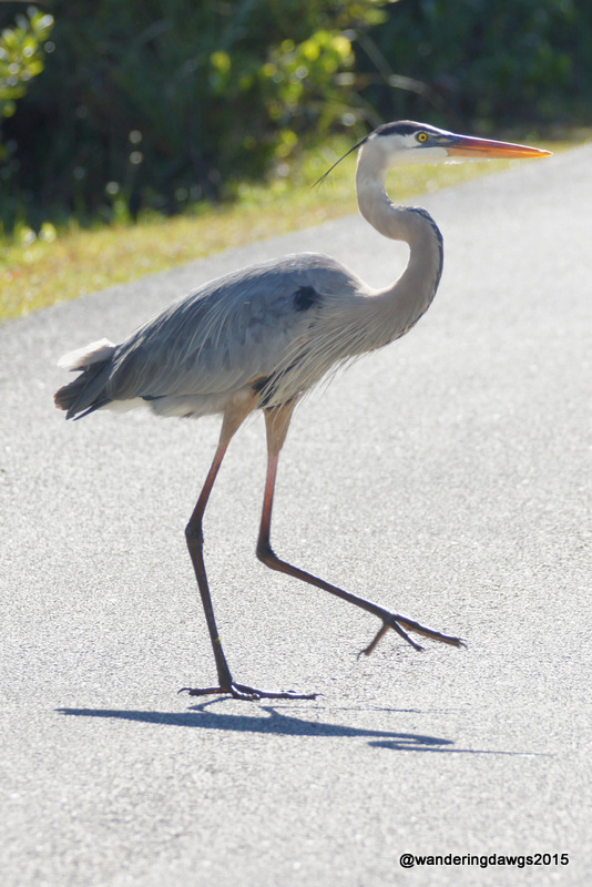
The next day we took a drive to the wildlife viewing area in the park with hopes of spotting some Roseate Spoonbills. The hiking trails were muddy and flooded in places so we passed on doing any hiking.  We enjoyed the views from an overlook and walked down a relatively dry trail to the kayak launching area. From the parking lot we stopped to watch some Egrets in a pond when I saw a splash of pink. A flock of Roseate Spoonbills entertained us before suddenly taking off.

Our campsite was in the beach campground at Galveston Island State Park. Our site was a paved back-in with a covered shelter, picnic table, fire ring, and water and electric hookups. The beach was just a short walk from the campsite. We enjoyed the park and wish we could have stayed longer.

Weekly Photo Challenge: Express Yourself

The WordPress Weekly Photo Challenge this week is: Express Yourself

Sometimes we like to take the RV and wander around Florida in January and February. Three years ago our wandering took us to the Midway Campground in the Big Cypress National Preserve. One day we drove to the Shark Valley Visitor’s Center in Everglades National Park to take the guided Tram tour on the 15 mile paved path through Shark Valley. The path is a popular place for bicycling and walking.

There is an abundance of wildlife to be seen there in the heart of the Everglades. We had a couple of up close and personal encounters with the wildlife that really stand out.

First was the alligator right in front of us that crossed from one side of the path to other. He didn’t care that there were tourists all around. Then there was the Great Blue Heron strutting across the road like he was king of the world.

This gator let us know this was his territory as he walked across the path
This is MY path!
This Great Blue Heron strutted across the path as if he owned it


Lake Chicot State Park, Arkansas

We continued exploring the Mississippi Delta at Lake Chicot State Park in Lake Village, Arkansas. Traveling south on Highway 165, a section of the Great River Road, we passed fields of cotton on both sides of the road.

The largest natural lake in Arkansas, Lake Chicot is also the largest natural oxbow lake in the United States. Our campsite was surrounded by wild pecan trees with a nice view of the lake. Our first day there, we drove across the mighty Mississipi River to Greenville, Mississippi to bring home 3 dozen delicious hot tamales.

Located in the Mississippi Flyway, the park is a great place for bird watching. In addition to egrets, herons and ducks, we were surprised to see a huge flock of White Peliicans on the lake.

We took a self guided driving tour along the Mississippi River levee. Most of the 20 mile tour was right on top of the levee. On one side of the levee were borrow pits with cypress trees, lily pads and many birds. On the other side was farmland.

We camped at Lake Chicot State Park in site 7 on October 21-22, 2014. For my review of this campground click here.

Crowley’s Ridge Parkway and the Great River Road in Arkansas

Driving on the Great River Road

Our home base to explore two scenic byways through the Mississippi Delta was Mississippi River State Park in Marianna, Arkansas. The large visitor’s center is less than 2 years old and has an excellent interpretive center about the Mississippi Delta area. The staff and rangers were friendly and helped make our stay here memorable.

The park is located in the Mississippi Delta on the Crowley’s Ridge Parkway and the Great River Road within the St. Francis National Forest. We stayed in the Beech Point Campground on a peninsula in Bear Creek Lake. It is one of the best state park campgrounds we have ever seen. There are only 17 sites in the campground with 14 full hookup waterfront sites and 3 tent sites.  Ours was a large pull through with a big patio area for the picnic table and fire ring. For my review of this campground click here.

This slideshow requires JavaScript.

To ask about exploring the area we talked to Park Ranger John as he was patrolling the campground. After getting directions, we had a plan for the next day.

Crowley’s Ridge rises 200 feet above the Mississippi River Delta flood plain and stretches more than 200 miles from just below Cape Giradeau, Missouri to Helana, Arkansas. The Crowley’s Ridge Parkway in Arkansas traverses the entire ridge. The section of the parkway we drove is called the “high road” by the locals.

The Great River Road and Crowley's Ridge Parkway run together for a few miles
The Great River Road and Crowley’s Ridge Parkway run together for a few miles

We started our drive to Helena-West Helena on the “high road”. On top of Crowley’s Ridge, the gravel road wound through the St. Francis National Forest. Only a few of the tall oaks, sycamore and buckeye trees had started showing any fall colors. The only other vehicles we saw belonged to hunters. I hope they had better luck with deer than we did. We only saw one all day. Except for a couple of National Forest campgrounds there was no other sign if civilization.

After about 20 miles we were back on a paved road and soon were on Cherry Street in Helena-West Helena to visit the Delta Cultural Center. Oh No! Closed on Monday! We felt like the Grizwalds when they got to Wally World to find it closed for repairs!

We took the “low road” back to the campground. This gravel section of The Great River Road is just a small part of the 10-state route from Canada to the Gulf of Mexico along both sides of the Mississippi River. In Arkansas the road rarely goes right beside the river.

As we drove along the “low road” we passed through Cypress swamps and took a side trip to the mouth of the St. Francis River where it joins the Mississippi River. With Willow Trees growing along the banks of the river, the mighty Mississippi is about a mile wide in this location.

This slideshow requires JavaScript.

We enjoyed two delicious meals from local restaurants that day. The meals were so memorable I will post about them in a later post. Stay tuned!

Smooth as Tennessee Whiskey

There is a line from the George Jones song “Tennessee Whiskey” that has been going through my head ever since we crossed the Tennessee State Line. It goes “You’re as smooth as Tennessee Whiskey”. There. Now it’s in your head, too.

Our first stop of our  fall trip was Barton Springs Campground, a TVA park in Normandy, Tennessee. We love waterfront camping so of course when I found this campground I made reservations for a site right on the water. The lake is down now during the off season but comes right in front of the campsite in spring and summer. This is a federal campground so you can use your Senior Pass to get a discount on your camping fee.

Sitting outside watching the lake was a great way to end the day after a 300 mile driving day which included going through Atlanta and Chattanooga. A doe and a fawn were across the lake grazing. A great blue heron stood on a point out in the lake. A couple launched their canoe and went for a paddle. And we were able to watch a pretty sunset.

Monday morning saw thunderstorms coming through the area. After breakfast we waited a little while for the rain to let up and then hopped in the truck to visit the Jack Daniel’s Distillery in Lynchburg, Tennessee. Jack Daniel was 13 years old when he bought his first still for $25. He developed the formula for his famous whiskey and the whiskey is still produced using the same formula and method. All the water used comes from an underground spring on the property, the barrels are still made by hand out of white oak, and the charcoal used for filtering the whiskey is made there from Sugar Maple wood. Jack was only 5 foot 2 and never married.

Our guide Janine told us the story of how Jack died. One morning Jack came to work early and tried to open the safe in his office. He was too impatient to wait for his nephew to arrive to open it so he kicked the safe and broke is big toe. He was too embarrassed to go to a doctor right away and when he finally saw one he had developed an infection which led to gangrene. He died as a result of this. It just goes to show you should never go to work early!

He left everything to his nephew shortly before prohibition shut all the distilleries down. His nephew opened a hardware store in town and made enough money to pay the property taxes every year. The distillery opened back up when prohibition was repealed.

This slideshow requires JavaScript.

After our full day of sightseeing Blondie took a swim in the lake and we ended the day with a Single Barrel Jack on the rocks.

Before we left the next day I took Blondie for one last walk along the lake and enjoyed watching a Great Blue Heron and 2 Egrets. A great ending to our enjoyable stay at Barton Springs.